Park Seismic LLC, Shelton, Connecticut, Tel: 347-860-1223, Fax: 203-513-2056, Email: parkseis@parkseismic.com
| ParkSEIS - Modeling Dispersion Image [*(*OT).dat] of Multichannel Seismic Data 1. Importing Input File |
There are two ways to import input data; by importing a layered-earth model file (*.LYR) or by importing previously saved file
(*.RFL) of entire modeling parameters including the input layered-earth model file.
For the first case, go to "Modeling" → "Seismic Data from Layered-Earth Model (*.LYR)" and then select a file.
(*.RFL) of entire modeling parameters including the input layered-earth model file.
For the first case, go to "Modeling" → "Seismic Data from Layered-Earth Model (*.LYR)" and then select a file.

For the second case of importing previously saved entire set of modeling parameters, including the layered-earth model (*.
LYR), go to "Modeling" → "Seismic Data from Saved List of Modeling Parameters (*.RFL)" and then select a file.
LYR), go to "Modeling" → "Seismic Data from Saved List of Modeling Parameters (*.RFL)" and then select a file.

| 2. Specify Acquisition Parameters and Execute Modeling |
To specify key modeling parameters (e.g., number of channels, receiver spacing, source offset, sampling interval, recording
time, etc.), click "Import Acquisition Parameters from Seismic File" to import a seismic data file. All parameters will be copied
from the first seismic record in the input file (if more than one record exist).
time, etc.), click "Import Acquisition Parameters from Seismic File" to import a seismic data file. All parameters will be copied
from the first seismic record in the input file (if more than one record exist).

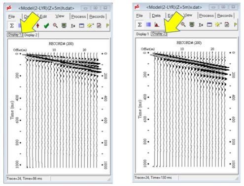
When the modeling is completed, then a seismic-data display window will appear with two tabs of displays; one for the vertical
component (*v.dat) in "Display 1" tab, and the other for the horizontal component (*h.dat) in "Display 2" tab as illustrated
below.
component (*v.dat) in "Display 1" tab, and the other for the horizontal component (*h.dat) in "Display 2" tab as illustrated
below.


To specify dispersion images are to be created also (corresponding to modeled seismic records), select "Dispersion" tab, and
then "Image" tab as shown below. Check the option "Generate image [*(OT).dat]."
Click "RUN" button and then the modeling will start the process by calculating seismic wavefields.
then "Image" tab as shown below. Check the option "Generate image [*(OT).dat]."
Click "RUN" button and then the modeling will start the process by calculating seismic wavefields.

Corresponding dispersion images will also be displayed as illustrated below for horizontal (top) and vertical (bottom)
components, respectively..
components, respectively..